LandMap: Property Line Finder
- 3.8
- Rating
- 100.00K
- Installs
- Free
- Price
 Analysis by App-foxy
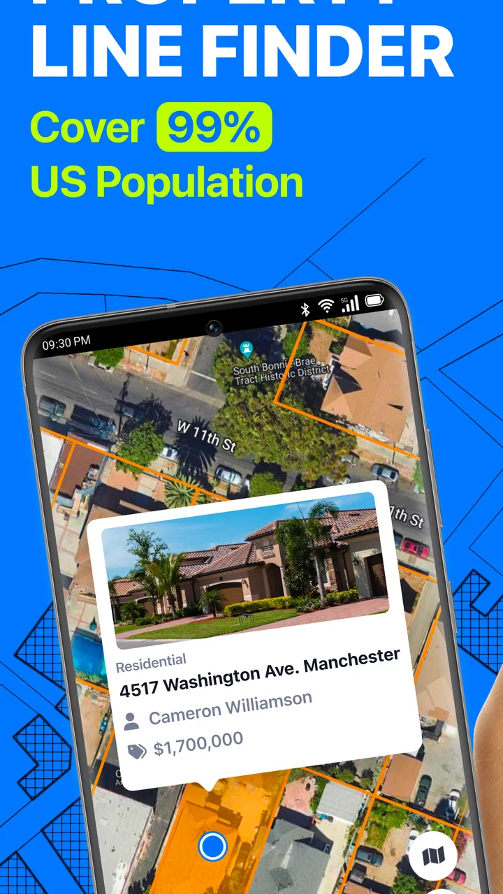
When I tested LandMap: Property Line Finder, I found that its most useful idea is also its clearest one: it puts property boundaries, parcel information, and ownership details into a map-focused tool instead of making me search through several unrelated sources. That makes it interesting for anyone trying to understand a piece of land before visiting it, discussing it, or comparing it with nearby parcels.
This is a free Maps & Navigation app from Astraler, available for Everyone and running on Android devices from version 8.1 onward. It has passed the point of being an obscure experiment, with over one hundred thousand installs, although its average score of 3.8 from around one thousand seven hundred ratings suggests that the experience is useful but not universally smooth. I think that is a fair starting point: LandMap can make property research more visual, but it should not be treated as a replacement for official surveying or legal documentation.
Property lines are the reason to install it
The central capability is viewing parcel boundaries on a map. That sounds simple, but it changes the first step of land research. Instead of beginning with an address, a paper document, or a general-purpose map that may show roads but not ownership divisions, I can begin with the shape and position of a parcel.
You May Also Like

 Blood Strike: 2.5 Anniversary
Blood Strike’s Loadouts Turn Every Drop Into a Tactical Gamble
A close look at Blood Strike’s custom loadouts: how fast access to signature weapons reshapes its battle royale rhythm, rewards preparation, and narrows the gap between fights.

 Pandora - Music & Podcasts
Pandora’s Music Is Easy to Start, but Harder to Recover
Pandora’s strength is its low-effort path from a seed to a station. Its weak spot is how much confidence it asks you to place in connection, setup, and quiet recovery.

 8 Ball Pool
 Is Built on Rivalries, Rematches, and Routine
A close look at the rivalries, rematches, shared routines, and unanswered safety questions that turn a quick pool match into a persistent mobile community.

 Samsung Music
’s Quiet Strength Is Playing What You Already Own
Its reach comes less from spectacle than from dependable access to a personal library. That simplicity is both the app’s strongest retention engine and its ceiling.

 AccuWeather: Weather Radar
AccuWeather Review: A Quick, Clear Forecast for Everyday Decisions
For everyday plans, the best forecast is the one you can understand quickly. AccuWeather makes rain timing, radar, and local conditions easy to act on, with a few trade-offs.

 Hill Climb Racing
Why Hill Climb Racing Still Turns Crashes Into One More Run
A tiny car, a bumpy hill and one more upgrade: Hill Climb Racing keeps resurfacing because its simple chaos makes every near-miss feel personal.
More From Our News Desk



That visual approach is particularly helpful when a property sits beside several similar lots. A written description may tell me a parcel number or street location, yet still leave me unsure which section of land it refers to. Seeing the boundary drawn in relation to roads and neighboring plots gives me a quicker sense of the layout. It is not the same as proving where a legal line lies on the ground, but it is a practical way to form an initial picture.
The app’s focus also makes it more relevant than a normal navigation application for this particular task. Google Maps and similar tools are excellent for finding an address, planning a route, or checking nearby businesses. They are not designed primarily around parcel research. LandMap is more specialized: its value appears when the question is not “How do I get there?” but “Which piece of land am I looking at, and how does it relate to the surrounding parcels?”
I would still keep the distinction between map information and legal certainty firmly in mind. A displayed line can help with orientation, conversations, and preliminary research, but a person planning construction, resolving a dispute, or buying land should use the relevant official records and professional advice as well. The strongest role for this app is as a convenient research layer, not as the final authority.
What the map view changes
The practical advantage is that parcel research becomes spatial rather than purely textual. When I look at a property in context, I can think about access roads, neighboring boundaries, the apparent size of adjacent lots, and how the parcel sits within the wider area. Those details are easy to miss when working from an address alone.
This is also where the app can save mental effort. I do not have to keep switching between a basic map for orientation and a separate source for parcel information during the first stage of investigation. The property finder concept brings those questions closer together, which is useful when I am screening several possible properties and only need a quick understanding of each one.
Ownership information adds another layer to that process. It can help me identify which parcel deserves further attention before I spend time gathering documents or arranging a visit. I see this as a filtering tool: it helps narrow down what I should investigate next, rather than pretending to complete the entire investigation inside one mobile app.
How I would use it in practice
I would begin with a clear purpose instead of opening the app and randomly exploring. For example, if I were considering a rural property, I would search for the location, inspect the parcel outline, and then look at neighboring lots. I would note whether the apparent boundaries match the description I have been given and whether the property seems to connect naturally with the road shown on the map.
That last point matters because access can be more complicated than an address suggests. A parcel may appear close to a road while its practical entrance is unclear, or it may sit among several lots with similar shapes. A map-based inspection cannot answer every access or easement question, but it can reveal which questions I need to ask before going further.
For a property owner, another useful workflow is preparing for a conversation with a neighbor, agent, or local office. I can first use the map to understand the parcel arrangement, then discuss the specific area with a clearer reference point. This is more productive than saying only that a line “looks wrong” without knowing which parcel or corner is being discussed.
I would also use it before a site visit. The app can help me form a rough mental map of the property and its surroundings, so I arrive knowing which neighboring parcels and roads to pay attention to. That makes the visit more focused. I can compare what I see on the ground with the map, while remembering that visible fences, hedges, driveways, and informal markers are not automatically legal boundaries.
One of my more useful habits with this type of tool is to record the context of what I am viewing rather than relying on memory. If I inspect multiple properties, I would write down the address or location, the parcel I intended to examine, and the questions raised by the map. That prevents a common mistake: confusing a nearby parcel with the one I originally meant to research.
A realistic everyday scenario
Imagine a friend sends me a listing for a house with a large yard and says the property may be suitable for an extension or a detached structure. Before I get excited about the available space, I would open LandMap and examine the parcel layout. I would look at how the lot meets the road, where neighboring parcels begin, and whether the apparent yard belongs to the property or simply looks connected from the street.
This does not tell me whether planning permission would be granted or whether construction is possible. It does something earlier and more basic: it helps me decide whether the listing deserves a closer look. If the parcel shape is much narrower than expected, or if the open area appears to belong to another lot, I can avoid building an entire plan around a misunderstanding.
For a family checking inherited land, the same workflow can make an unfamiliar area less confusing. A relative who has not visited the property for years may recognize the road name but not the current parcel arrangement. A visual map can provide a shared starting point for discussing which land is being considered, especially when several nearby properties have similar addresses.
Where the experience needs caution
The first trade-off is confidence. A clean boundary line on a phone screen can feel more definitive than it really is. I would not use the app alone to place a fence, settle a boundary disagreement, sign a purchase agreement, or make a costly construction decision. Those situations require authoritative records and, where appropriate, a qualified surveyor.
The second trade-off is that useful information depends on the location being examined. Parcel mapping is not equally helpful everywhere, and the amount of ownership detail available to a user can vary by area. I would therefore treat the first search as a test: if the location is represented clearly enough for my purpose, the app becomes valuable; if the result is incomplete or difficult to interpret, I would move to local records rather than forcing the app to answer a question it cannot settle.
There is also a learning curve in interpreting parcel maps. Someone unfamiliar with land records may mistake a parcel outline for a visible feature on the ground or assume that ownership and occupancy are identical. The app can show information in a more accessible format, but it does not remove the need to understand what that information means.
The free entry point is welcome, especially for occasional research. However, in-app purchases range from $4.99 to $99.99 per item, so I would pay attention before committing to anything beyond basic use. That wide range means the cost can become important for people who expect to conduct extensive property research. I would first establish whether the app covers my location and solves my immediate problem before considering any purchase.
Another limitation is that LandMap is not the right tool for every navigation task. If I need turn-by-turn driving directions, traffic awareness, transit planning, or a broad travel map, a mainstream navigation service is a better fit. LandMap earns its place when the property itself is the subject, not when the journey to it is the main concern.
How it compares with familiar alternatives
A general map application usually wins for speed and everyday travel. I already know how to use one to search an address, check a route, or identify nearby services. LandMap is narrower, but that narrowness is useful because it puts parcel lines and property context closer to the center of the experience.
Government land-record portals may be more appropriate when I need official documentation, formal ownership records, or a legally dependable source. Their weakness is often convenience: they can be less comfortable on a phone, harder to browse visually, or organized around record searches rather than quick map exploration. LandMap sits earlier in the process, helping me decide what to investigate and where to look.
Real-estate listing apps are better for comparing homes, prices, photographs, and listing descriptions. They may show a property on a map, but that does not necessarily make parcel boundaries the main object of the experience. LandMap is more useful when the land layout matters independently of the sales presentation.
In my view, the best approach is not choosing one tool for everything. I would use a normal map for travel, a listing service for market context, LandMap for parcel orientation, and official records or a professional for decisions that carry legal or financial consequences. The app becomes much more effective when used as one step in that chain rather than as a complete replacement for all of it.
Who gets the most value
LandMap is a good match for property owners who want a quick visual reference, buyers screening rural or unfamiliar lots, families discussing inherited land, and people preparing questions before contacting an office, agent, or surveyor. It is also useful for anyone who thinks spatially and finds a parcel outline easier to understand than a page of written descriptions.
Its value is strongest during early research. I can use it to eliminate obvious misunderstandings, compare the surrounding layout, and decide which property deserves deeper attention. That can make a short phone session surprisingly productive, particularly when I am dealing with several nearby parcels.
I would recommend skipping it if I only need ordinary directions, if I expect a definitive legal boundary, or if I am unwilling to verify important details through authoritative sources. It is also a poor fit for someone who wants a complete real-estate buying service, because its focus is the map and property context rather than the whole transaction.
My final view after using it
LandMap: Property Line Finder has a sensible purpose and delivers its strongest value by making parcel research visual. I like that it encourages me to look at a property in relation to its neighbors instead of treating an address as the whole story. That can prevent simple but expensive misunderstandings at the beginning of a property search.
At the same time, the app requires disciplined use. I would treat its lines and ownership information as a starting point for questions, not as permission to make legal or construction decisions. The middling 3.8 average reflects the fact that a specialized mapping tool can be genuinely helpful while still depending heavily on location, interpretation, and the user’s expectations.
Version 2.0.7 is worth trying for people who regularly investigate land and want a mobile-first way to inspect parcel context. Since it is free to start and rated for Everyone, the barrier to testing the basic experience is low. My recommendation is simple: use it before the official research, during property comparison, and ahead of a site visit, then verify anything important elsewhere. Its real strength is helping me ask better property questions sooner.
FAQs for LandMap: Property Line Finder
01What is LandMap: Property Line Finder used for?
LandMap: Property Line Finder is designed to help users explore property boundaries, parcels, and land-related information using an interactive map. It can be useful when researching a property, checking neighboring lots, planning outdoor projects, or learning more about land ownership records. However, the app should be treated as a reference and research tool rather than a replacement for an official survey or legal property documentation.
02Can LandMap accurately show my exact property lines?
The app can provide a convenient visual estimate of property boundaries based on available mapping and public-record data, but its accuracy may vary by location. Parcel information can be outdated, incomplete, or displayed with limited GPS precision. Before making decisions about construction, fencing, purchasing land, or resolving a boundary dispute, users should confirm the information with the local authority, title documents, or a licensed land surveyor.
03Does LandMap: Property Line Finder work everywhere?
Coverage and available features depend heavily on the country, state, county, or other local area selected. Some regions may offer detailed parcel boundaries and ownership-related data, while others may provide only basic map information or no suitable records at all. It is a good idea to check whether your location is supported before relying on the app for property research or planning.
04Does the app require GPS, internet access, or personal information?
LandMap may use location services to center the map around your current position, although users can generally search for other places manually. An internet connection may be necessary to load maps, parcel layers, and updated records. Depending on the version and enabled features, the app may request location or other permissions. Review the permission prompts and privacy policy carefully, and disable access that is not necessary for your intended use.
05Is LandMap suitable for legal, surveying, or real-estate decisions?
LandMap can be helpful during preliminary research, but it should not be considered an official legal source. Screen boundaries and map overlays may not represent surveyed corners, easements, right-of-way areas, or the exact description recorded in a deed. For transactions, disputes, permits, construction, or any decision involving legal responsibility, compare the app’s information with official county records and consult a qualified real-estate professional or licensed surveyor.
Pros
- Clear map overlays make property boundaries easy to inspect.
- Useful for checking nearby parcels while viewing land in the field.
- Location tools help identify your position on mapped properties.
- Simple interface is approachable for occasional users.
- Helpful starting point for land research before contacting professionals.
Cons
- Boundary data may be outdated
- incomplete
- or inaccurate in some areas.
- Many useful features may require a subscription or in-app purchase.
- Coverage and detail can vary significantly by location.
- GPS accuracy may drop near buildings
- trees
- or in remote terrain.
- Not a substitute for a licensed survey or legally verified property records.

LandMap: Property Line Finder
Gallery